Featured Post

The wrong trail can be worse than a Dad Joke

It's time to start thinking about getting the family out on the slopes for some much needed fresh air, exercise and time away from zoom....

Monday, October 31, 2011

How soon will she be off the bunny hill?

video

Last season I taught a 4 and half year old student named Mina.  As you can see from the video above, she's adorable.  But I'm posting this to highlight what's really important in ski lessons.  We ski instructors often discuss this amongst ourselves, and when possible, with parents.

Mina's parents' primary concern (after Mina's safety, of course) was that their daughter have fun. This puts them in that great group of parents who get it.

How fast she progressed wasn't important, creating a love of skiing was.

So this was an awesome lesson for multiple reasons:
  • Mom & Dad get it, and were "no-stress" parents.
  • Mina had fun, and is psyched for this season.
  • Mom and Dad were ecstatic.  

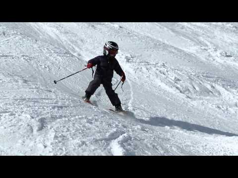
The fact that in four short hours, Mina was skiing without an edgy-wedgy and was off the Big Easy is a small source of pride, but in my humble opinion, in the grand scheme of things, it's irrelevant. Below is the actual video of Mina on her way off the bunny slope... It doesn't feature her smiling face, but Mom and Dad like it anyway.

video

Thursday, October 27, 2011

Tahoe Weather Geek - The source for snow news

For those of us who plan our ski or snowboarding trips based on long term forecasts, the best source I know is the Tahoe Weather Geek.  The weather guru who posts his forecasts at Tahoeloco.com is a good writer and tends to be really accurate.  You can also sign up for email notification, and whenever a significant weather event is imminent, he sends one out.


Today's email had this to say:
"A weak ridge of high pressure building over the region will mean a warming trend over the weekend, with high temperatures back to around normal by Sunday, perhaps a few degrees above normal.
But the change will be shortlived. Another low pressure system is expected to push past the Tahoe region Monday and Tuesday, bringing a return to cooler day time highs and, in its wake, perhaps some frigid lows. This system, however, is looking like it will stay mostly to our north, so its precipitation potential is slight.
Further out, it is beginning to look like we could begin to see a significant change in our weather by the middle of next week. The high pressure is forecast to move further west into the Pacific, opening the door for storms to reach us from the Gulf of Alaska. If all goes well, this could signal the beginning of the winter snow season."


The last piece of news is that my calendar below has been updated with new Google Appointment Slot technology.  It allows users with a gmail account to click on and reserve a lesson block with me.  Anyone can see the availability. You still need to call the school to confirm the lesson, but blocking it on my calendar sends me an email and lets me email or call the school to hold the date until you're able to call.  If you are wanting to book an all day lesson, simply reserve both the morning and afternoon spot. 


If you want to bookmark and go directly to a less busy appointment slot calendar, here's the link to that.  If you click it today, you won't see any available slots and will have to scroll forward to November 18th... the first day of the season!


Thursday, October 20, 2011

Another great snow year in store, according to Dr. Jeff Masters

My good friend Matt Gregory works for WeatherUnderground, and he's an awesome source for weather news. He just passed along this link to a great winter forecast. Skiers and riders, get psyched.

Here's an excerpt, but I highly recommend visiting the full article to see a great graphic and read more.
------------
NOAA winter forecast: drought in Texas, wet in the Northwest and Ohio Valley
By Dr. Jeff Masters


The Southern Plains should prepare for continued drier and warmer than average weather, while the Pacific Northwest is likely to be colder and wetter than average from December through February, according to the annual Winter Outlook released October 20 by NOAA. We currently have weak La Niña conditions over the tropical Pacific ocean, which means that a large region of cooler than average waters exists along the Equator from the coast of South America to the Date Line. Cooler than average waters in this location tend to deflect the jet stream such that the Pacific Northwest experiences cooler and wetter winters than average, while the southern U.S. sees warmer and drier winter weather. NOAA's forecast calls for a typical La Niña winter over the U.S.--warm and dry over the Southern Plains, cool and wet over the Pacific Northwest, and wetter than average over the Ohio Valley. According to NOAA's latest La Niña discussion, La Niña is expected to remain solidly entrenched throughout the coming winter and into spring.